Sentinel-3 Products
Terrascope offers Sentinel-3 data products. The Sentinel-3 mission is part of the European Copernicus programme, which provides Earth observation data for environmental monitoring and civil security. The Sentinel-3 mission is composed of two satellites, Sentinel-3A and Sentinel-3B, which are equipped with a suite of instruments to monitor the Earth’s oceans, land, ice and atmosphere. The mission provides a range of data products, including ocean colour, sea surface temperature, land surface temperature, vegetation indices, fire detection, and more.
Land surface temperature
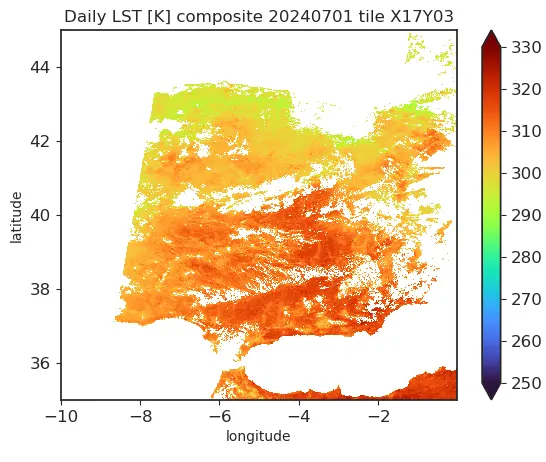
Sentinel-3 Level 3 Land Surface Temperature daily synthesis product - V1
The Sentinel-3, Level 3 Land Surface Temperature S1 products (S3_LST_3_S1) contain 1 km daily LST composites. TMeasurements are provided on a regular latitude-longitude grid, with an equatorial sampling distance of approximately 1 km (1° / 112). The LST and LST_unc are provided, derived from unflagged S3_SL_2_LST inputs at minimum viewing zenith angle.
| Property | Value |
|---|---|
| Spatial extent | [-180.0, -65.0, 180.0, 75.0] |
| Temporal extent | 2018/09/22 - Current |
| DOI | 10.71570/atpb-0551 |
The Algorithm Theoretical Basis Document (ATBD) for this collection can be found here.
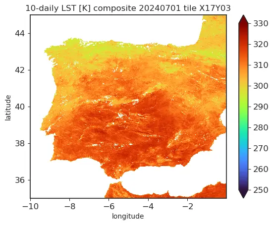
Sentinel-3 Level 3 Land Surface Temperature 10-daily synthesis product - V1
The Sentinel-3, Level 3 Land Surface Temperature S10 products (S3_LST_3_S10) contain 1 km 10-daily LST composites. TMeasurements are provided on a regular latitude-longitude grid, with an equatorial sampling distance of approximately 1 km (1° / 112). The LST and LST_unc are provided. LST is derived as the mean value of unflagged S3_LST_3_S1_V1 inputs. LST_unc is propagated from S3_LST_3_S1_V1 inputs
| Property | Value |
|---|---|
| Spatial extent | [-180.0, -65.0, 180.0, 75.0] |
| Temporal extent | 2018/09/22 - Current |
| DOI | 10.71570/w1wx-w194 |
The Algorithm Theoretical Basis Document (ATBD) for this collection can be found here.
Vegetation
Sentinel-3 Level 2 Synergy 1 km VEGETATION-Like daily synthesis TOC reflectance and NDVI - V1
The Sentinel-3, Level 2 Synergy VG1 products (SY_2_VG1) contain 1 km VEGETATION-like TOC reflectances and NDVI. The ‘1 km VEGETATION-like product’ label means that measurements are provided on a regular latitude-longitude grid, with an equatorial sampling distance of approximately 1 km (1° / 112). The NDVI is provided, derived from surface reflectances in B2 and B3.

| Property | Value |
|---|---|
| Spatial extent | [-180.0, -90.0, 180.0, 90.0] |
| Temporal extent | 2018/09/22 - Current |
| DOI | 10.71570/fgce-2j71 |
Sentinel-3 Level 2 Synergy 1 km VEGETATION-Like 10-daily synthesis TOC reflectance and NDVI - V1
The Sentinel-3, Level 2 Synergy V10 products (SY_2_V10) contain 1 km VEGETATION-like TOC reflectances and NDVI. The ‘1 km VEGETATION-like product’ label means that measurements are provided on a regular latitude-longitude grid, with an equatorial sampling distance of approximately 1 km (1° / 112). The NDVI is provided, derived from surface reflectances in B2 and B3.
| Property | Value |
|---|---|
| Spatial extent | [-180.0, -90.0, 180.0, 90.0] |
| Temporal extent | 2018/09/22 - Current |
| DOI | 10.71570/h2y6-vx73 |
Note on Sentinel-3 Level 2 Synergy VEGETATION product quality
Users of the SYN VGT products should be aware that the SYN VGT products archive suffers from a number of quality issues that heavily impact the consistency with SPOT/VGT and PROBA-V, such as:
- Absolute radiometric calibration issues of the SLSTR sensor, with unapplied SWIR vicarious calibration adjustments, impacting consistency of the SWIR band (MIR channel). This was corrected in a processing baseline update in July/2023.
- The use of SPOT4/VGT1 spectral response functions in the spectral resampling procedure, with large differences with PROBA-V relative spectral responses, especially in the red band (B2 channel). This was corrected in a processing baseline update in July/2023.
- An issue was discovered in the spectral resampling procedure, leading to incorrect band re-mapping of OLCI and SLSTR bands to the PROBA-V-like response. This was corrected in a processing baseline update in July/2023.
- Overestimation of AOT in the atmospheric correction (e.g., Wolters et al., 2021)
- Until May 2021, the V10 NDVI product was erroneously based on TOA reflectances.
- Limited global coverage of daily composite products because S3A and S3B observations are not combined in one synthesis product. Since the swath width of Sentinel-3/OLCI is smaller than SPOT/VGT or PROBA-V, the combination of OLCI onboard Sentinel-3 A and B is needed to obtain similar coverage.
- Currently, no cloud shadow detection is performed in the SYN processing chain.
- Occasionally, there are problems with availability of S3 SYN VGT products, with missing products (e.g. June/2021), empty products (e.g. July/2021), or products having an incorrect date (e.g. December/2020).The frequency of this type of issues has increased since January/2025, related to the migration of the Sentinel-3B processing centre.
More information can be found in (Toté et al., 2024) and in monthly Data Quality Reports and the Annual Performance Reports, available at the Sentinel-3 document library.