ESA WorldCover Product
The ESA WorldCover Product provides an 11-class Land Cover classification for the base year 2020 and was published in October 2021. Future updates will be on a yearly basis, with the aim of having the updates ready within 3 months from the latest Sentinel-1 and -2 observations to be included.
Below short descriptions of the algortihm, product data content, and data access are given. More detailed information on the methodology, limitations, and product validation can be found in the WorldCover Product User Manual.
Algorithm
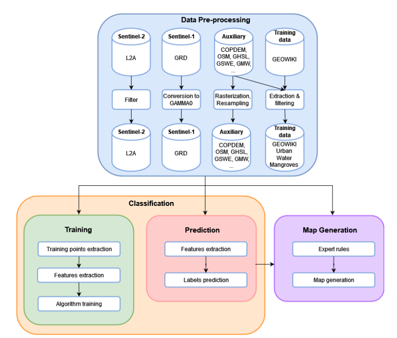
The combined WorldCover workflow is summarized in Figure 1. It comprises three main components: the data pre-processing, classification (training and prediction), and the map generation.
In the data pre-processing, as a first step Sentinel-1 GRD files are terrain-corrected to Gamma0 backscatter, while Sentinel-2A Level-2A data are filtered for cloud cover. Subsequently, the Sentinel-2 data are further filtered for cloud shadows, pixel saturation, and cirrus using the Scene Classification Layer (SCL), and 10-day median reflectance composites are generated. Missing values are linearly interpolated and finally Vegetation Indices from these composite time series are calculated. …
In the training phase, these features are extracted for each training location, from which training points are randomly sampled, with a maximum of 20 points per class per location.
In the classification phase, the same steps are carried out until the features are extracted, at that point the models/scenarios trained during the training phase are loaded and used to predict the labels of the input data together with the class probabilities.
Finally, the different scenarios are combined into a final land cover map through the application of different expert rules and subsequently tiled into 3 x 3 degree tiles in geographic projection (EPSG:4326).

Figure 1: WorldCover algorithm schematic.
Product data content
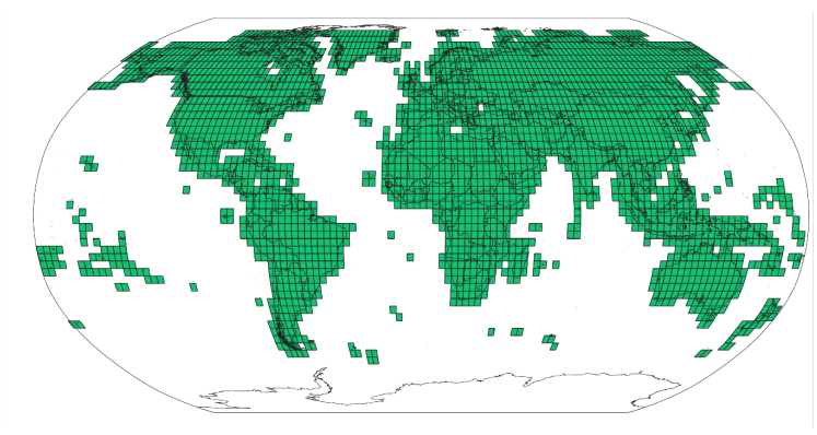
The ESA WorldCover products are provided per 3 x 3 degree tile (Figure 2), 2651 in total. Each tile contains a set of 2 Cloud Optimized GeoTIFF (COG) files corresponding to the following data layers:
- Map: Land cover map with 11 classes
- InputQuality: Three band GeoTIFF providing three per pixel quality indicators of the Sentinel1 and Sentinel-2 input data The tiles are provided in EPSG:4326, geographic latitude/longitude CRS.

Figure 2: WorldCover tiling grid.
The GeoTIFF files follow this naming convention:
ESA_WorldCover_10m_<YEAR>_<VERSION>_<TILE>_<LAYER>.tif e.g.
ESA_WorldCover_10m_2020_v100_S48E036_Map.tif
where
- “ESA_WorldCover_10m” indicates this is the 10 m resolution ESA WorldCover product
<YEAR>indicates the reference year (observation period) in four digits (e.g. 2020)<VERSION>shows the product version. The version denoted as vMmr (e.g. v100), with ‘M’ representing the major version (e.g. v1), ‘m’ the minor version (starting from 0) and ‘r’ the production run number (starting from 1)<TILE>the designation of the 3 x 3 degree tile, composed of the 2-digit latitude and 3-digit longitude of the lower-left corner (Figure 2) Example: S48E036 for the tile covering the area from 36E to 39E and 48S to 45S.<LAYER>gives the name of the data layer (Map or InputQuality)
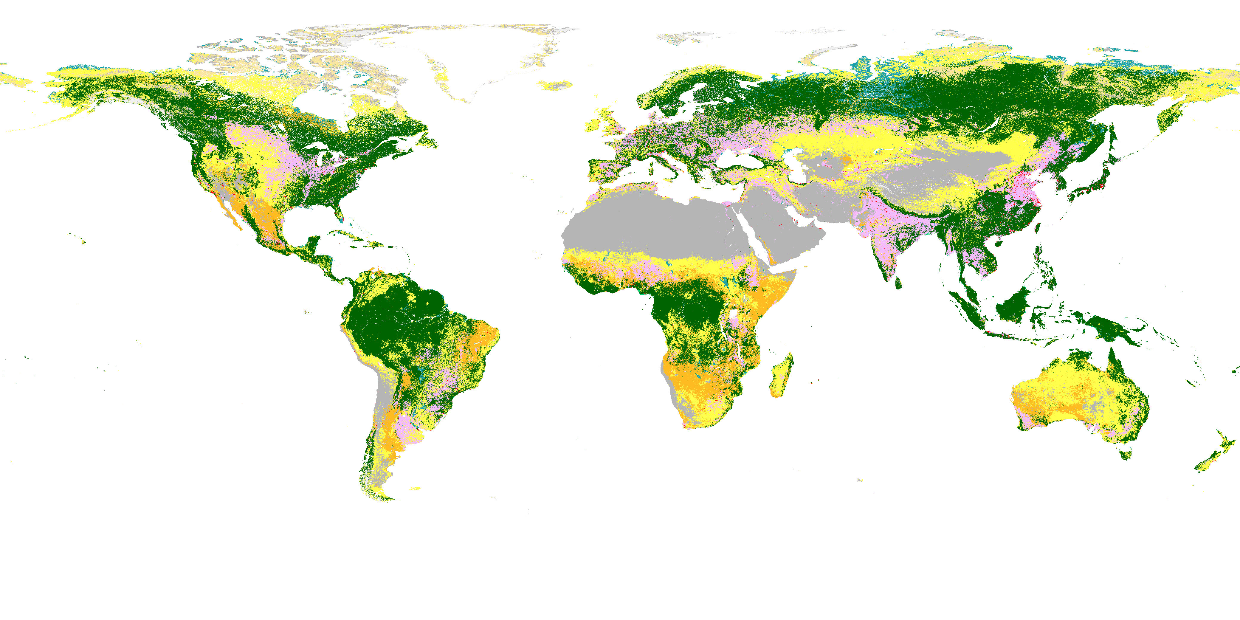
ESA WorldCover Global Land Cover Map for 2020, at 10 meter resolution in COG format
ESA WorldCover 2020 is a global Land Cover Map for 2020 at 10 meter resolution. It is released in COG format in 3 x 3 degree latlon tiles. The map for 2020 was produced using v100 of the algorithm. WorldCover provides the first global land cover products for 2020 and 2021 at 10 m resolution, developed and validated based on Sentinel-1 and Sentinel-2 data.
| Property | Value |
|---|---|
| Spatial extent | [-180, -60, 180, 83] |
| Temporal extent | 2020/01/01 - 2020/12/31 |
ESA WorldCover Sentinel-2 yearly NDVI percentiles composite 2020, 10 meter COG format
The ESA WorldCover Sentinel-2 yearly NDVI percentiles composite is released per 1 x 1 degree tile.
| Property | Value |
|---|---|
| Spatial extent | [-180, -60, 180, 83] |
| Temporal extent | 2020/01/01 - 2020/12/31 |
ESA WorldCover Sentinel-1 GAMMA0 median composite 2020, 10 meter COG format
3 bands, VV median, VH median, VH/VV median, Radiometric Terrain Corrected SAR Backscatter, power scaled.
| Property | Value |
|---|---|
| Spatial extent | [-180, -60, 180, 83] |
| Temporal extent | 2020/01/01 - 2020/12/31 |
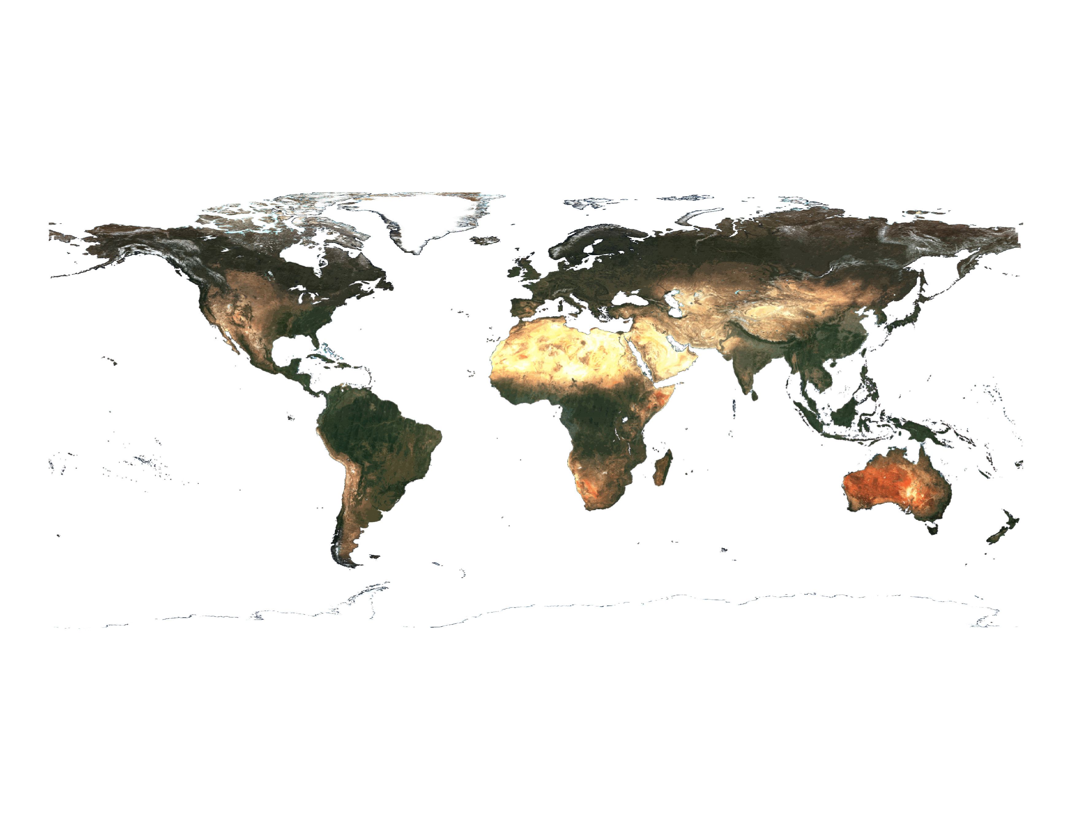
ESA WorldCover Sentinel-2 RGBNIR median composite 2020, 10 meter COG format
The ESA WorldCover Sentinel-2 RGBNIR median composite is released per 1 x 1 degree tile.
| Property | Value |
|---|---|
| Spatial extent | [-180, -60, 180, 83] |
| Temporal extent | 2020/01/01 - 2020/12/31 |
ESA WorldCover Sentinel-2 yearly SWIR median composite 2020, 20 meter COG format
The ESA WorldCover Sentinel-2 yearly SWIR median composite is released per 1 x 1 degree tile. They are composed of a yearly median of the B11 and B12 20m SWIR bands. This offers additional information for the mapping of water and vegetation.
| Property | Value |
|---|---|
| Spatial extent | [-180, -60, 180, 83] |
| Temporal extent | 2020/01/01 - 2020/12/31 |
ESA WorldCover Global Land Cover Map for 2021, at 10 meter resolution in COG format
ESA WorldCover 2021 is a global Land Cover Map for 2021 at 10 meter resolution. It is released in COG format in 3 x 3 degree latlon tiles. The map for 2021 was produced using v200 of the algorithm. WorldCover provides the first global land cover products for 2020 and 2021 at 10 m resolution, developed and validated based on Sentinel-1 and Sentinel-2 data.
| Property | Value |
|---|---|
| Spatial extent | [-180, -60, 180, 83] |
| Temporal extent | 2021/01/01 - 2021/12/31 |
ESA WorldCover Sentinel-2 yearly NDVI percentiles composite 2021, 10 meter COG format
The ESA WorldCover Sentinel-2 yearly NDVI percentiles composite is released per 1 x 1 degree tile.
| Property | Value |
|---|---|
| Spatial extent | [-180, -60, 180, 83] |
| Temporal extent | 2021/01/01 - 2021/12/31 |
ESA WorldCover Sentinel-1 GAMMA0 median composite 2021, 10 meter COG format
3 bands, VV median, VH median, VH/VV median, Radiometric Terrain Corrected SAR Backscatter, power scaled.
| Property | Value |
|---|---|
| Spatial extent | [-180, -60, 180, 83] |
| Temporal extent | 2021/01/01 - 2021/12/31 |
ESA WorldCover Sentinel-2 RGBNIR median composite 2021, 10 meter COG format
The ESA WorldCover Sentinel-2 RGBNIR median composite is released per 1 x 1 degree tile.
| Property | Value |
|---|---|
| Spatial extent | [-180, -60, 180, 83] |
| Temporal extent | 2021/01/01 - 2021/12/31 |
ESA WorldCover Sentinel-2 yearly SWIR median composite 2021, 20 meter COG format
The ESA WorldCover Sentinel-2 yearly SWIR median composite is released per 1 x 1 degree tile. They are composed of a yearly median of the B11 and B12 20m SWIR bands. This offers additional information for the mapping of water and vegetation.
| Property | Value |
|---|---|
| Spatial extent | [-180, -60, 180, 83] |
| Temporal extent | 2021/01/01 - 2021/12/31 |
Product data access
The dataset can be accessed and/or downloaded in different ways:
WorldCover viewer The WorldCover viewer is a simple web-mapping tool that allows users to navigate the globe visualizing the ESA WorldCover product without installing any software. Furthermore, it also allows users to compare the map with Sentinel-1 and Sentinel-2 median composites for 2020, view land cover statistics per administrative area, and provides the possibility to give feedback on the product. Finally, users can also use the viewer to download the WorldCover product, either by administrative area, or customized region of interest.
Google Earth Engine app A dedicated Google Earth Engine App has been made which allows users to visualize the ESA WorldCover product and compare with Sentinel-1 and Sentinel-2 composites for 2020.
Web Map Service The ESA WorldCover product can also be used within other websites or GIS clients by ‘Web Map Services’. These services provide a direct link to the cached images and are the best option if you simply want to map the data and produce cartographic products. They are not suitable for analysis as the data are represented only as RGB images.
WMTS: https://services.terrascope.be/wmts/v2
WMS: https://services.terrascope.be/wms/v2
Layer: WORLDCOVER_2020_MAP
Example:
- Data download The dataset can be downloaded from:
- WorldCover viewer (Login required)
- Navigate to the WorldCover viewer
- Register for VITO’s Terrascope platform (see the link in the top right).
- Log in the WorldCover viewer with your Terrascope credentials
- From the ‘Download’ tab in the WorldCover viewer, zoom to an area of interest or draw a polygon to retrieve the list of tiles covering that area. The platform will zip the tiles and initiate the download.
- Navigate to the WorldCover viewer
- Terrascope with Python (Login required)
Tiles can be downloaded programmatically using Python and theterracatalogueclientpackage. Please use your Terrascope credentials to download and then: Install the terracatalogueclient or run
pip install --extra-index-url https://artifactory.vgt.vito.be/artifactory/api/pypi/python-packages/simple terracatalogueclient
- WorldCover viewer (Login required)
See for more details on methodology, data content and access, as well as the product validation the WorldCover Product User Manual.


